For most regulatory efforts such as §404 permit activity, you are strongly advised to use the Corps of Engineers Wetland Delineation Manual.
However, other sources of information and identification are available such the NRCS Toolkit. The investigator must assume responsibility for determining how much and what quality data are necessary for each project.
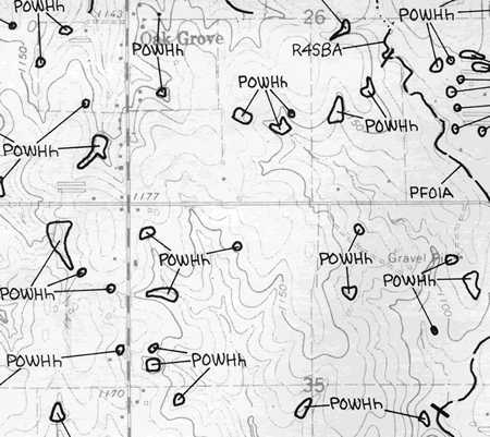
Using only one source of information will lead to unsupportable decisions. National Wetland Inventory maps are a valuable start to your delineation efforts but you must remember that many of these maps have never been "ground truthed" and therefore will outline areas that aren't necessarily wetlands. Some have been but it's been quite a while since that happened. Look closely at one of these maps. There is a very good chance that wetlands aren't going to be round. At the same time, there may be wetland areas that are not shown on the maps because they weren't wet or vegetated at the time of the fly-over.
This is why you need to be sure and actually go on-site to perform some sort of delineation. This is where you should employ a widely accepted protocol such as the Corps 1986 manual as above. An artificially created waterbody, even a round one, may still possess the requisite hydric indicators if it's been around long enough.
Interpretting these maps can be a little confusing. Looking at the bottom of any of these maps in the traditional paper format will reveal a confusing listing of codes and modifiers. These all refer to the hydrologic regime of the area as well as the vegetation type (as interpretted from fly-over photos). The tables on the following page should simplify the Cowardin system of classification.
So, if you have a code that says "POWHh", it will mean Palustrine, Open Water, permanently flooded, diked. Meaning that this waterbody was artificially created by someone, probably to water livestock. "R4SBA" means riverine, intermittent, streambed, temporarily flooded. This area is likely seasonally wet, possibly by "overbank" flooding or backwater flooding. Follow the link on the next page to the Cowardin Code page and look up some codes on your map.
Investigators are strongy advised to follow steps simliar to the following in order to definitively determine the presence or absence of wetlands.
Anything short of an actual on-the-ground field investigation is going to be insufficient for the purposes of a delineation or a "presence/absence" determination.
Be aware, though, the absence of a single indicator may not preclude the existence of a wetland at that location. It may be concluded from the presence of hydric soils that the appropriate hydrology is present. The same can be said for wetland obligate vegetation (see following section on vegetation). In order to properly delineate a wetland, evidence of all three requirements must be shown within a contiguous area.